I lost track of waterfalls as I saw several small ones cascading down tall canyons on the way to Sohra or Cherrapunjee. I have to mention one thing here. Whenever I asked the driver how many more kilometers to reach the spot, the answer never used to come back in kilometers, but in time. They measure distances by time taken to reach from once place to another! Sohra is around 58 km from Shillong and we were about to invade the pristine beauty of the wettest place in the world, its unusual facets, the perpetual clouds, and the perpetual mists….
 |
| Cherrapunjee |
 |
| Cherrapunjee |
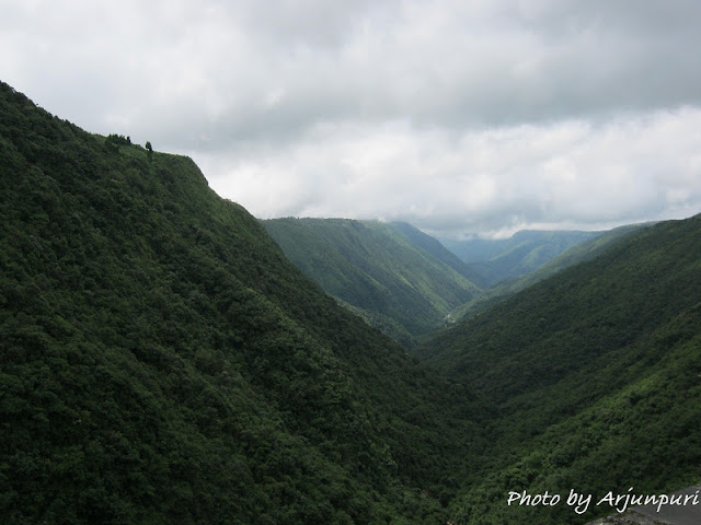
Driver Guddu stopped the car at Duwansing Syiem View Point, where we saw a map of different viewpoints in and around Sohra. The speciality of the bridge at this viewpoint was that nothing on the opposite side of the Mawkdoh bridge was visible! It was more than an ordinary experience to be at a place which was high above misty valleys and foaming rivers, ensconced in swirling clouds and perched on an escarpment and the topmost ‘wet’ place in the world. From this bridge started the Sohra sector which gave us spectacular views with deep gorges along the side of the road and plateaus running parallel across the gorges.
Sohra is the local Khasi term derived from ‘Soh-niamtra’, means oranges. The British used to call the place as ‘Churra’ which eventually evolved into the current name, Cherrapunjee. The word ‘Cherrapunjee’ means land of oranges.
Sohra has an average elevation of 1,484 metres (4,869 ft) and sits on a plateau in the southern part of the Khasi Hills, facing the plains of Bangladesh. The plateau rises 600 meters above the surrounding valleys. Valleys around Sohra were covered with lush and very diverse vegetation, containing numerous endemic species of plants, including Meghalaya subtropical forests.
Sohra holds two Guinness world records for receiving the maximum amount of rainfall in a single year: 22,987 millimetres (75.417 ft) of rainfall between August 1860 and July 1861 and for receiving the maximum amount of rainfall in a single month: 9,300 millimetres (30.5 ft) in July 1861.
The most interesting thing about this place is, despite perennial rainfall, it faces an acute water shortage and the inhabitants often have to trek for miles to obtain potable water. Irrigation is also hampered due to excessive rain washing away the topsoil as a result of human encroachment into the forests. Soils on the plateau are poor due to deforestation and washout caused by heavy rains. Due to winter droughts the vegetation in this location is even xerophytic in spite of the fame of Cherrapunjee as extremely wet place. A notable feature of monsoon rain at Sohra is that most of it falls in the morning!


The faces of Sohra change not with the seasons, but with the pattern of rainfall. The heaviest downpours span approximately five long months from May to September and we were in a way lucky as the rains didn’t spoil our trip and in a way unlucky as we couldn’t become a part of the rain :( Just imagine how romantic it would be when the raindrops beat incessantly on rooftops and treetops creating a compelling tattoo of awesome sounds, which cannot be savoured in Doha, but only in India! Even a gentle patter of rain would have made our trip to Sohra much more beautiful :) Watching people walking slowly under the umbrellas, the flora and the fauna drenching in the rain… When rain stops seeing soft pastel shades appearing in skies that were gray all the day… Oh, I’m asking for too much ;) I wish we had gone to Sohra in the evening to experience an out-of-the-world exhiliration, stay the night and watch the mystery unfolding itself in the early morning!
After clicking several photos, we moved towards Ramakrishna Mission.


 Sohra has an average elevation of 1,484 metres (4,869 ft) and sits on a plateau in the southern part of the Khasi Hills, facing the plains of Bangladesh. The plateau rises 600 meters above the surrounding valleys. Valleys around Sohra were covered with lush and very diverse vegetation, containing numerous endemic species of plants, including Meghalaya subtropical forests.


 The most interesting thing about this place is, despite perennial rainfall, it faces an acute water shortage and the inhabitants often have to trek for miles to obtain potable water. Irrigation is also hampered due to excessive rain washing away the topsoil as a result of human encroachment into the forests. Soils on the plateau are poor due to deforestation and washout caused by heavy rains. Due to winter droughts the vegetation in this location is even xerophytic in spite of the fame of Cherrapunjee as extremely wet place. A notable feature of monsoon rain at Sohra is that most of it falls in the morning!


No comments:
Post a Comment